As previously reported, the NERC-funded EMERGE Project has brought together scientists, researchers and early warning specialists from across Iceland, Norway and Scotland including the Scottish Environment Protection Agency. Following successful exploratory workshops in Oslo (May 2022) and Glasgow (March 2023), it was the Icelandic Meteorological Office (Veðurstofa Íslands) who hosted the final project event during the week of the 8th to 11th May.
The Icelandic Meteorological Office (IMO) are responsible for monitoring, informing, forecasting and providing warnings for natural hazards. In no other country that the project has been exposed to, can you observe such challenges around extreme and multiple natural hazards including the impacts of volcanic ash and extreme flooding. As witnessed on a guided tour of the Svínafellsjökull glacier and surrounding area, there is a real feeling of living on the edge of potentially extreme hazards.

The workshop was attended by staff and specialists from IMO, Iceland’s search and rescue team (ICE-SAR), University of Iceland, the Civil Protection Authority and the Icelandic national broadcasting authority, who were recording a podcast on natural hazards in the country.

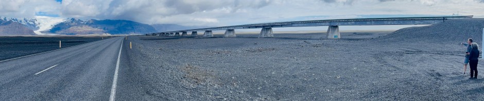
As discussed, glacial floods (jökulhlaup) present the greatest risk to people in Iceland, with 1 to 3 per decade causing significant damage to bridges, roads and infrastructure. “Medium sized floods are those with a maximum discharge of several thousand cubic metres per second”, and, as illustrated by various speakers, the scale of the issue is being made greater, with mass tourism in the past decade increasing the risk exposure.
One point was made by both the IMO and the Civil Protection Authority (Almannavarnir), in that there is a fine balance between timely warnings, when you only have 45-60 minutes warning for a typical jökulhlaup, and false warnings… “always be open about communicating uncertainty” was the key message from the Almannavarnir representative Ágúst.

Reflecting on the common challenges and issues across the three countries, one question has been consistent… are these risks worse in remote regions given the lack of monitoring? Although all organisations are working towards improved observational networks where needed. Tourism, whilst not unique, is certainly a bigger challenge in Iceland and how to warn of immediate hazards with such a transient population. It’s interesting that the IMO have already embraced cell broadcasting as a regular form of communication given the recent Emergency Alerts trial in the UK. Also, whilst the use of the risk matrix is common across Iceland, Norway and Scotland, so is the challenge of ‘yellow fatigue’ and communicating uncertainty and low confidence events.
The EMERGE Project has developed successful collaboration and sharing of ideas, and is unique in focusing on remote regions and multiple hazards. There will be more to follow from the project, including a planned publication around project learning, including warning communication where at-risk customers have differing appetites for information and dealing with compound events.
